The printable version is no longer supported and may have rendering errors. Please update your browser bookmarks and please use the default browser print function instead.
Description
map_id = map_add(x,y,width,height,source,zoom)
map_add is used to add a map to your instrument. You can add any openstreetmap as a base layer for your map. Note that an internet connection is required as the base layer is fetched from the openstreetmap servers directly.
Return value
| Argument |
Type |
Description
|
| map_id |
ID |
This value can be used for further reference. Functions such as map_goto can use this map_id. Its good practice to store this map_id in your logic code.
|
Arguments
| # |
Argument |
Type |
Description
|
| 1 |
x |
Number |
This is the most left point of the canvas where your map should be shown.
|
| 2 |
y |
Number |
This is the most top point of the canvas where your map should be shown.
|
| 3 |
width |
Number |
The map width in pixels.
|
| 4 |
height |
Number |
The map height in pixels.
|
| 5 |
base_layer |
String |
The openstreetmap base layer to use. See available base layers below. Use 'nil' if you don't want any base layer at all.
|
| 6 |
zoom |
Number |
The openstreemap zoom level. This value can normally range from 1 (whole earth) to 16 (closest to earth). This value is dependent on the base layer source type defined above.
|
Base layers
| Tag |
Name |
Zoom levels |
Example
|
| OSM_STANDARD |
OpenStreetMaps map |
1-17 |

|
| OSM_CYCLE |
Cycle map |
1-17 |

|
| OSM_TRANSPORT |
Transport map |
1-17 |

|
| OSM_HUMANITARIAN |
Humanitarian map |
1-17 |

|
| OSM_STAMEN_TERRAIN |
Stamen Terrain |
1-13 |
|
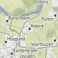
Example
-- Place a map to your instrument using the openstreetmap cycle map and zoom level of 10
id = map_add(0,0,500,500,"OSM_CYCLE", 10)

-- Goto the beautiful city of Nijkerk, the Netherlands
map_goto(id, 52.222607, 5.485053)


